Papago Park was my first Phoenix hike. It was right across the street from our first apartment. It was my first Phoenix Instagram post (#nofilter). It’s where my puppy went on her first walks, and where we shot our engagement photos. I’ve hiked there with friends and family of all ages. And when we bought our first home, I didn’t really want to be too far away from the sight of these iconic red buttes.

If you are visiting Phoenix for the first time or want an introduction to Sonoran Desert scenery, get Papago Park on your list. It’s the perfect short jaunt for after-work sunset sightings, or to try trail running, mountain biking or scrambling up the sides of the buttes off-trail.
The park also shares a footprint with two of Phoenix’s best attractions, the Desert Botanical Garden and Phoenix Zoo.
Getting There
Papago Park is divided by Galvin Parkway into east and west sides. The east side boasts Hole in the Rock, a famous formation you can climb into after a short hike, plus fishing lagoons, trails and the curious pyramid tomb of Arizona’s Governor Hunt. The west side is best for hiking and offers loop trails around sandstone buttes.
There are two parking lots to access the west side. The more accessible lot is located off of Galvin Parkway, and there’s also a tiny pullout along eastbound McDowell Road, if you just want to start from the amphitheater. The east side has plenty of parking near Hole in the Rock and surrounding the lakes.
Papago Park East
I snuck in from my preferred parking lot near the canal. These bighorn sheep may be living life on the edge, but they are far from wild: They’re Phoenix Zoo residents coming to watch the sunrise.


Governor Hunt’s Tomb
What on earth is that white pyramid on the hillside overlooking the park? A 1930s tomb for an eclectic governor, of course. George Hunt is entombed here with his wife and some close family members. His interest in Egyptian history inspired the shape, and I suppose his chops as a politician permitted him the unconventional burial place in the middle of town.
You can get here and enjoy the views by walking up the trail that leads from a parking lot below.


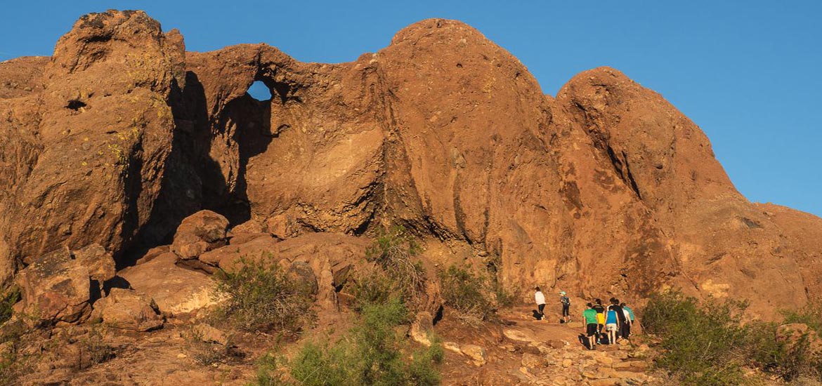
Hole-in-the-Rock
This natural sandstone “cave” is accessible from a .3-mile uphill walk, and peeks out over the lagoons below toward downtown Phoenix. It’s a great viewpoint without a lot of work, which also means you’ll be sharing it with several other onlookers. Come for a sunset and stake out a spot inside the rock opening to watch, or if you are daring, climb up onto the landmark.


Hole-in-the-Rock refers not to the large opening, but a smaller hole in the top that Phoenix’s ancient masterminds of civilization planning—the Hohokam—used to track the seasons.


The ponds
You can fish from these three palm-lined ponds, or just enjoy the reflections.


Papago Park West
It’s your hike, your way on the trails around the buttes on the west side of the park. The main path is the Double Butte Loop, which takes you 2 miles around both formations. You can also access the Little Butte Loop, or climb onto the butte itself. The Big Butte Loop circles the formation closest to McDowell Road and through the amphitheater on the north side. The CCC built these stone seats back in the 30s, and the 3,500-person amphitheater historically housed Easter sunrise services; now it’s solely used for runners getting their heart rate up on a morning exercise routine.

Obviously be careful, but the buttes are fun to climb off-trail. There are alcoves and great views up there.
As a creature of habit, my path when hiking Papago Park is to start off on the west side of the Double Butte Loop, running uphill to the Little Butte and walking around the top, then walking to the ramada in the middle before circling the Big Butte.

Bonus: Tempe’s Papago Park
Since I live just blocks east of the park, I sneak in from the Crosscut Canal Path starting near Evelyn Hallman Pond. My typical route is to actually cut south into what my husband and I unofficially refer to as “Tempe Papago,” or the trails around Curry Road.
There is an entire system back here for climbing on buttes and following trails through wild desert. It’s an after-work ritual in the cooler months before the sun sets. We’ve also played disc golf in the course off of Mill Ave.

If you want to really spend some time out here, there is a tunnel under Curry that connects the upper and lower half of the trails. Climb the Loma Trail to the ramada, and you’ll be elevated for views of the 202 freeway and beautiful skyline of downtown Tempe over the water. You’ll also be standing on the ruins of Loma del Rio, an ancient Hohokam ruin. I like the sensation of watching roaring traffic and sleek buildings from 1500-year-old stones.
